Examining the Perspectives of Geographic Information Science Professionals Toward a Geospatial MetaDACUM
Introduction
This research study used Q Methodology to assess respondents' perceptions of the meta-tasks within the National Geospatial Technology Center of Excellence's (GeoTech Center) Geospatial MetaDACUM.
Problem Statement
Various researchers have attempted to capture the skills needed for workers to succeed in the geospatial field. Historically, there has been a lack of external input from Geographic Information Science Professionals (GISPs) regarding geospatial competencies. What input there was did not force participants to discriminate between the relative importance of the competencies and sought feedback from the field without consideration of occupation.
Purpose Statement
The purpose of the study is to explore the viewpoints of GISPs toward the GeoTech Center Geospatial MetaDACUM and why they hold these views. By assessing viewpoints toward these competencies, the researcher can better understand how they view core geospatial competencies.
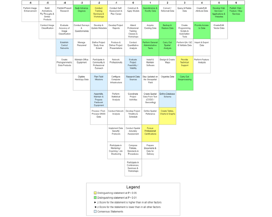
Finding 1. This study revealed four viewpoints, representing the different perspectives of GISPs participating in the research project. The emergent factors were: Factor 1: We Develop and Provide Access to Data; Factor 2: Data Development is More Important than Support Systems; Factor 3: We Support the Larger Geospatial Community; Factor 4: Analysis and Geoprocessing are our Forte.
Finding 2. The respondents shared some broad-spectrum impressions regarding the perceived relevance of the meta-tasks located within the GeoTech Center Geospatial MetaDACUM. Meta-tasks viewed as most relevant were split between the three general categories data management, cartographic publishing, and analysis. The meta-tasks viewed as least relevant aligned with fieldwork, photogrammetric, and professional development activities.
Finding 3. The Q-sorts produced six consensus statements between the factors, which is not surprising, given the number of qualifying respondents (38) and the generation of factors (4). The two highest-scoring consensus statements, Statements 4 and 7, were related to data activities. All of the negatively-ranked meta-tasks, Statements 10, 11, and 12, involved fieldwork. The remaining consensus statements, Statement 42, dealt with project management.
Conclusion
This study represented the results of an investigation to address how GISPs view the meta-tasks located within the GeoTech Center Geospatial MetaDACUM. The researcher collected data from 44 GISPs, with 38 respondents loading onto four factors. The themes developed from the analysis include Factor 1: We Develop and Provide Access to Data; Factor 2: Data Development is More Important than Support Systems; Factor 3: We Support the Larger Geospatial Community; Factor 4: Analysis and Geoprocessing are our Forte.
The respondents did not reveal unanimity concerning the apparent value of the meta-tasks located within the GeoTech Center Geospatial MetaDACUM but did produce six consensus statements between the factors (all non-significant at p<0.01). Meta-tasks viewed as most relevant were split between the three general categories data management, cartographic publishing, and analysis, and the meta-tasks viewed as least relevant are associated with fieldwork, photogrammetric, and professional development activities.
This research study validates using a Q Methodological study as a practical approach to examining the statements within a competency model. Moreover, it demonstrated a process using industry professionals to evaluate a conceptual model of competencies. This study provided feedback from GISPs regarding how they perceive the meta-tasks in the GeoTech Center Geospatial MetaDACUM.