UAS MetaDACUM: Meta-Task Assessment
Introduction
This research study used Q Methodology to assess respondents’ perceptions of the meta-tasks within the National Geospatial Technology Center of Excellence’s (GeoTech Center) UAS MetaDACUM.
Problem Statement
There has historically been a lack of external input from practitioners regarding their views towards UAS competencies. What input there was did not force participants to discriminate between the relative importance of the competencies.
Purpose Statement
The purpose of the study is to explore the viewpoints of UAS practitioners toward the GeoTech Center UAS MetaDACUM and why they hold these views. By assessing UAS practitioners’ viewpoints toward these competencies, the researcher can better understand how they view core UAS competencies. Also, the identification of commonalities across viewpoints may reveal widely held beliefs within the field.
Finding 1. This study revealed three viewpoints, representing the different perspectives of UAS practitioners participating in the research project. The three documented factors characterize a substantial variation in the perceptions of technical UAS meta-tasks. The emergent factors were Factor 1: We Love to Work with Data; Factor 2: We are First and Foremost UAS Pilots; and Factor 3: We Believe in Mission Preparation.
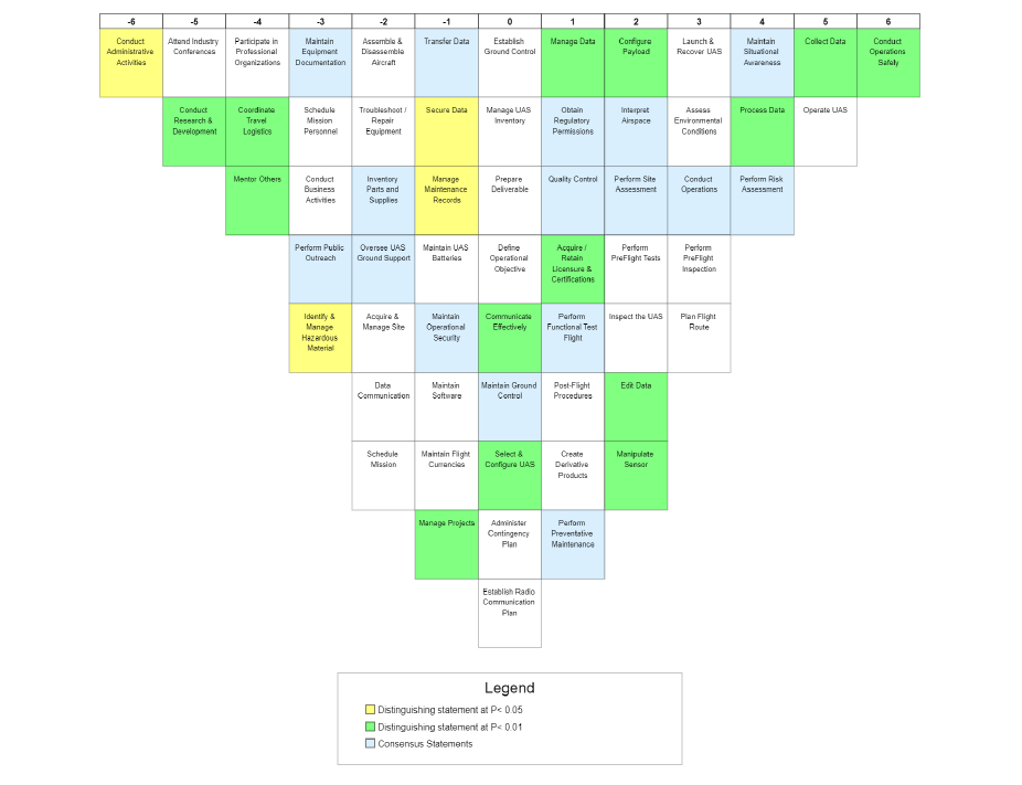
Finding 2. The respondents shared some general impressions regarding the perceived relevance of the meta-tasks located within the GeoTech Center UAS MetaDACUM. Meta-tasks aligned with the safe conduct of UAS operations dominated the composite scores with four of the eight highest-rated meta-tasks. Furthermore, the eight meta-tasks with the paramount level of consensus related to UAS safety. Meta-tasks viewed as less relevant were split between the three general categories of professional support activities, administrative, and maintenance.
Finding 3. The Q-sorts produced 16 consensus statements between the factors, which is not surprising, given the number of respondents (19) and the generation factors (3). As mentioned previously, the meta-tasks exhibiting the greatest consensus related to the safe conduct of UAS operations. There were a total of 16 consensus statements, 11 of which are significant at p< 0.01.
Conclusion
This study represented the results of an investigation to address how UAS practitioners view the meta-tasks located within the GeoTech Center UAS MetaDACUM. The researcher collected data from 19 UAS practitioners, with all respondents loading onto three factors. The study gathered demographic, Q-sort (quantitative), and narrative (qualitative) data. To address the research question (How do UAS practitioners view the UAS meta-tasks located within the GeoTech Center UAS MetaDACUM, and why?), the researcher performed factor analysis on the Q-sort submissions
and generated three factors. The post-sort questionnaire provided additional information and critical insight to the researcher, who used the qualitative data to build the narratives for each factor. The themes developed from the analysis include Factor 1: We Love to Work with Data; Factor 2: We are First and Foremost UAS Pilots; and Factor 3: We Believe in Mission Preparation.
This research study validates using a Q Methodological study as a practical approach to examining the statements within a competency model. Moreover, it demonstrated a process using industry representatives to evaluate a conceptual model of competencies. This study provided feedback from UAS practitioners regarding how they perceive the meta-tasks in the GeoTech Center UAS MetaDACUM.