2014 Lifetime Achievement In Geospatial Two-year College Education
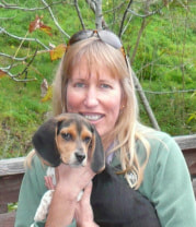
Deidre Sullivan is the director and PI of the Marine Advanced Technology Education (MATE) Center and has been with the organization since its inception. The MATE Center is a national partnership of community colleges, high schools, universities, informal educational organizations, research institutions, marine industries, and professional societies. MATE’s mission is to use marine technology to create interest in and improve STEM education and to provide the marine technical workforce with well-educated STEM professionals. MATE was established as an Advanced Technological Education (ATE) Center of Excellence in 1997 with funding from the National Science Foundation and currently continues as an NSF ATE Resource Center. Headquartered at Monterey Peninsula College (MPC) in Monterey, California, the Center has built a national reputation as a leader in advancing marine technical education, particularly with respect to workforce assessment and development. On example of MATE’s successful programs are its network underwater robotic competitions which engage thousands of students each year.
Deidre has Bachelor’s degrees in Aquatic Biology and Geology and Master’s degrees in Marine Science and Geoscience and graduate minors in GIS and Marine Resource Management. Deidre has been a college educator for 20 years and has taught courses in GIS, Marine Remote Sensing, and Oceanography using Google Earth and student-built ocean drifters to observe ocean processes. Deidre was the PI and lead author for the NSF grant and report A Plan for the National Coordination of Geospatial Technology Education from a Community College Perspective. Prior to these activities Deidre worked as a marine geologist mapping the ocean floor, ran the largest scuba program for teenagers in the world on Catalina Island, started an underwater video production company, and worked extensively in informal education. Deidre is a Member of the Women Diver’s Hall of Fame and is currently on the Monterey County Water Resources Agency’s Board of Directors.
Deidre has Bachelor’s degrees in Aquatic Biology and Geology and Master’s degrees in Marine Science and Geoscience and graduate minors in GIS and Marine Resource Management. Deidre has been a college educator for 20 years and has taught courses in GIS, Marine Remote Sensing, and Oceanography using Google Earth and student-built ocean drifters to observe ocean processes. Deidre was the PI and lead author for the NSF grant and report A Plan for the National Coordination of Geospatial Technology Education from a Community College Perspective. Prior to these activities Deidre worked as a marine geologist mapping the ocean floor, ran the largest scuba program for teenagers in the world on Catalina Island, started an underwater video production company, and worked extensively in informal education. Deidre is a Member of the Women Diver’s Hall of Fame and is currently on the Monterey County Water Resources Agency’s Board of Directors.
2014 Distinguished Geospatial Educator Award

Nicole Ernst holds Bachelor of Arts degrees in political science (Slippery Rock University) and environmental studies (Montana State University) and a Master of Arts degree in Geography from East Carolina University. In her professional career, she has worked as a cartographer for the National Park Service at Bighorn Canyon in Montana/Wyoming and then for the Outer Banks Group of parks in North Carolina. Additionally, in 2002-2003 Nicole worked on the Wright Brothers Centennial Celebration Planning team that was tasked with organizing the 100th anniversary of flight. After leaving the National Park Service, Nicole worked as a GIS Analyst for the Berks County Agricultural Land Preservation Board where she used GIS analysis to annually rank farms for easement protection. Nicole began her teaching career in 2005 when she started teaching GIS for Harrisburg Area Community College (HACC) and currently teaches all the GIS courses in the geospatial technology curriculum. In addition to her teaching and advising load, Nicole manages the Mine Mapping grant awarded from the Pennsylvania Department of Environmental Protection (DEP) where over a three year period HACC will scan, georeference, and digitize 500 anthracite maps that will eventually become part of Pennsylvania’s Mine Map Atlas (http://www.minemaps.psu.edu/).
Every year since 2009, Nicole has served as co-chair for the Central Pennsylvania GIS Day event which is a partnership between HACC and the Commonwealth of Pennsylvania. This event that offers 20-30 sessions, an exhibit hall, and a map gallery brings together high school students, college students, GIS professionals, and GIS enthusiasts.
Nicole is an active member of several GIS and Geography organizations such as the Pennsylvania Mapping and and Geographic Information Consortium (PAMAGIC), where she serves as a board member and is editor for a statewide GIS publication, PAMAGIC Matters. She also serves as a board member for the Pennsylvania Alliance for Geographic Education. Additionally, she is a member of the Pennsylvania GIS Conference Planning Committee and the Pennsylvania Geographical Society.
2014 Geospatial Education Partner Award

Directions Magazine is the leading source of geospatial information technology, news and commentary for “all things location.” We keep our readers informed with the latest geospatial technology trends and issues through newsletters, blogs, podcasts, industry Channels and webinars. Our readers gain an “inside edge” by reading our publications and attending our events. We maintain the industry’s largest and most knowledgeable editorial and management team, each member having substantial experience as a practitioner of geospatial technology. This allows Directions Magazine to not only report on current news and applications, but also provide commentary and advice on industry trends. And we are driven to serve our advertisers by bringing them broad exposure through our worldwide reach. Read our publications daily: Directions Magazine (www.DirectionsMag.com), Directions Magazine India (www.directionsmag.in) and All Points Blog (www.AllPointsBlog.com). Attend our conferences: Location Intelligence Summit in the USA and Brazil (www.LocationIntelligence.net) and the GEO Huntsville Conference (www.GEOHuntsville.com ). Contact us at [email protected].

