
Geospatial Education Awards
Discover free public data, tools, and resources from GeoTech Center
|
2022 National Excellence in Geospatial Education Awards Recipients
|
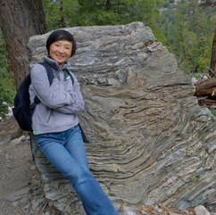
Jing Liu
|
Distinguished Geospatial Educator
Jing Liu Santa Monica College, Santa Monica, California Jing Liu, a full-time instructor in Santa Monica College, CA. She received her PhD from University of Wisconsin Madison. She participated the Geospatial Educator's Certification Program (GeoEdC) and won the Award of Distinguished Geospatial Educator.
|
Heidi Ragsdale
|
Lifetime Achievement
Heidi Ragsdale Middle School Science Teacher - STEM / GIS Heidi's life's work includes: 20 years in the middle school science classroom, with an emphasis on STEM and Problem/Place-Based Learning. The passion from that work allows her to ensure that formal and informal rural educators and their students have access to innovative technology to increase the amount of explorers and problem solvers within local and regional communities. These tools include interactive web-based mapping tools as well as engineering design programs to showcase innovative solutions. Providing opportunities in STEM and GIS, helps build the workforce of tomorrow.
20 year STEM/CTE, ESL, ESRI T3G, Nat Geo Grantee, NG Teacher Advisory Council, STEMEd Diversity Equity / Inclusion. Colorado Key Women Educators. Maptivist & GeoArtist. |
|
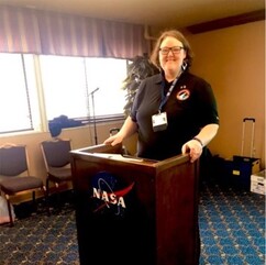
URISA

Kevin Mickey
|
Distinguished Education Partner
URISA 701 Lee St, Suite 960, Des Plaines, IL 60016 URISA, The Urban and Regional Information Systems Association is a multi-disciplinary geospatial organization that provides professional education and training, a vibrant and connected community, advocacy for geospatial challenges and issues, and essential resources. URISA fosters excellence in GIS and engages geospatial professionals throughout their careers.
The award accepted by Kevin Mickey, an Immediate Past President of URISA and Director of Professional Development and Geospatial Technologies Education at The Polis Center, an applied research center at IUPUI. |
