
Curriculum Resources
This page contains curriculum resources for geospatial educators at the secondary, college, and university levels. Have a recommendation? Share it!
Integrated Geospatial Education and Technology Training Project (iGETT)
The Integrated Geospatial Education and Technology Training Project (iGETT) will help meet workforce demands for geospatial technologists by enabling two-year colleges to expand existing Geographic Information Systems (GIS) programs to incorporate a wide range of remote sensing applications. The iGETT website offers student exercises that integrate GIS and remote sensing and a wide range of other resources that support instruction in remote sensing."
The Integrated Geospatial Education and Technology Training Project (iGETT) will help meet workforce demands for geospatial technologists by enabling two-year colleges to expand existing Geographic Information Systems (GIS) programs to incorporate a wide range of remote sensing applications. The iGETT website offers student exercises that integrate GIS and remote sensing and a wide range of other resources that support instruction in remote sensing."

Spatial Literacy and Awareness Course Materials from Europe
The Training Kit has been developed with the objective "to support the spread of 'good practice' in generating, managing, analysing and communicating community spatial information".
The Training Kit has been developed with the objective "to support the spread of 'good practice' in generating, managing, analysing and communicating community spatial information".

A Free and Open Source Software (FOSS4G) Tutorial
The site's aim is to provide detailed workflow guides using free and open source software. The target audience is beginners to intermediate users. The ultimate aim is to get more people using foss in their businesses.
The site's aim is to provide detailed workflow guides using free and open source software. The target audience is beginners to intermediate users. The ultimate aim is to get more people using foss in their businesses.
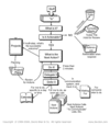
Resource Clearinghouse Workflow Model
This Logic Model, provided by Vince DiNoto of Kentucky Community College. This model is useful to design a clearinghouse workflow model.
This Logic Model, provided by Vince DiNoto of Kentucky Community College. This model is useful to design a clearinghouse workflow model.

Teaching With Data Dot Org
TeachingWithData.org is portal of teaching and learning resources for infusing quantitative literacy into the social science curriculum. A Pathway of the National Science Digital Library, TwD aims to support the social science instructor at secondary and post-secondary schools by presenting user-friendly, data-driven student exercises, pedagogical literature, and much more! Resources are available on a wide range of topics and disciplines.
TeachingWithData.org is portal of teaching and learning resources for infusing quantitative literacy into the social science curriculum. A Pathway of the National Science Digital Library, TwD aims to support the social science instructor at secondary and post-secondary schools by presenting user-friendly, data-driven student exercises, pedagogical literature, and much more! Resources are available on a wide range of topics and disciplines.

San Diego Mesa College GIS Modules
Geospatial curriculum modules designed specifically for K12 teachers across multiple disciplines. These learning modules feature a variety of technology platforms, including: Google Earth, ArcGIS Explorer, ArcGIS, GeoMapApp, Internet-based maps. Requires little more than a browser and Internet connection.
Geospatial curriculum modules designed specifically for K12 teachers across multiple disciplines. These learning modules feature a variety of technology platforms, including: Google Earth, ArcGIS Explorer, ArcGIS, GeoMapApp, Internet-based maps. Requires little more than a browser and Internet connection.

Scripps Institute Online Explorer
Since 2001 the collection has matured to include five federated collections: SIO Cruises, SIO Historic Photographs, the Seamounts, Marine Geological Samples, and the Educator’s Collection, all part of the US National Science Digital Library (NSDL). The effort is collaboration among researchers at Scripps, computer scientists from the San Diego Supercomputer Center (SDSC), and archivists and librarians from the UCSD Libraries.
Since 2001 the collection has matured to include five federated collections: SIO Cruises, SIO Historic Photographs, the Seamounts, Marine Geological Samples, and the Educator’s Collection, all part of the US National Science Digital Library (NSDL). The effort is collaboration among researchers at Scripps, computer scientists from the San Diego Supercomputer Center (SDSC), and archivists and librarians from the UCSD Libraries.
GEOGRAPHY 4 Kids.Com
Thanks for visiting! Right now you're on GEOGRAPHY4KIDS.COM. If you are looking for physical geography or earth science basics, stay on this site. It's not just for geography for kids, it's for everyone. This site has an introduction to the earth sciences that includes topics on the Earth's structure , atmosphere , hydrosphere , and biosphere (for a start). If you're still not sure what to click, try our site map that lists all of the topics on the site. If you surf and get lost in all of the information, use the search function on the side of the pages.
Thanks for visiting! Right now you're on GEOGRAPHY4KIDS.COM. If you are looking for physical geography or earth science basics, stay on this site. It's not just for geography for kids, it's for everyone. This site has an introduction to the earth sciences that includes topics on the Earth's structure , atmosphere , hydrosphere , and biosphere (for a start). If you're still not sure what to click, try our site map that lists all of the topics on the site. If you surf and get lost in all of the information, use the search function on the side of the pages.

My NASA Data Lesson Plans
The collection of MY NASA DATA lesson plans is intended to provide the educator with a variety of specific examples, incorporating a more "teacher-directed" strategy, of how authentic satellite data can be integrated into the curriculum.
The collection of MY NASA DATA lesson plans is intended to provide the educator with a variety of specific examples, incorporating a more "teacher-directed" strategy, of how authentic satellite data can be integrated into the curriculum.

Photo Press Release
Sample photo release form for public events you wish to photograph, such as your annual GIS Day event.
Sample photo release form for public events you wish to photograph, such as your annual GIS Day event.

Dual Credit Vs. AP Courses
For top high school students, the sales pitch for dual-credit classes is almost irresistible – pass one class and get high school and college credit. Yes, the classes are harder and require more work, but they look good on college applications and students are better prepared for university courses, students are told. For most, the classes pay off. They start college with part of their degree requirements out of the way. But a few are surprised to find that their classes are not as readily accepted by universities as they thought they would be.
For top high school students, the sales pitch for dual-credit classes is almost irresistible – pass one class and get high school and college credit. Yes, the classes are harder and require more work, but they look good on college applications and students are better prepared for university courses, students are told. For most, the classes pay off. They start college with part of their degree requirements out of the way. But a few are surprised to find that their classes are not as readily accepted by universities as they thought they would be.

Geospatial Glossary
The mission of wiki.GIS.com is to ensure your success. Whether you’re a GIS expert or have just recently started using GIS, we deeply appreciate the opportunity to serve you. Wiki.GIS.com is a knowledge sharing platform that will enable users to share their knowledge with the community. Wiki.GIS.com will be useful in enhancing our knowledge of GIS, and will help geographers better understand GIS concepts and quickly ramp up their GIS skills to be more productive.
The mission of wiki.GIS.com is to ensure your success. Whether you’re a GIS expert or have just recently started using GIS, we deeply appreciate the opportunity to serve you. Wiki.GIS.com is a knowledge sharing platform that will enable users to share their knowledge with the community. Wiki.GIS.com will be useful in enhancing our knowledge of GIS, and will help geographers better understand GIS concepts and quickly ramp up their GIS skills to be more productive.
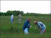
Spatial Logistics Curriculum
The field of Logistics is rapidly changing, as web-based and other digital technologies transform how goods travel from one place to another. This revolution in how business takes place is fueled by both a globalized economy and rapid growth of technology.
Global industry needs efficient transport of resources and products so new technologies are invented. At the same time, these new technologies have made possible the rapid globalization in the first place. The business that finds and uses a new technology that increases efficiency first has a competitive advantage. Then, other competitors have to be ready to adopt the new technology also. All of this creates a powerful cycle of growth and change.

GIS Career & Education Awareness
The GIS Career & Education Awareness website is dedicated to the education of future GIS professionals and increasing general awareness of GIS technology. To achieve the goals of educating GIS professionals and increasing GIS awareness this website has compiled resources explaining what GIS is and how it can be used, designed online tools that showcase GIS related tasks, provided links to GIS programs and educational resources, and created a certification program using GIS learning modules via the web.
The GIS Career & Education Awareness website is dedicated to the education of future GIS professionals and increasing general awareness of GIS technology. To achieve the goals of educating GIS professionals and increasing GIS awareness this website has compiled resources explaining what GIS is and how it can be used, designed online tools that showcase GIS related tasks, provided links to GIS programs and educational resources, and created a certification program using GIS learning modules via the web.

Web Based GIS to Teach Problem Solving Science in High School and College
Foothill College has partnered with San Jose State University to bring web mapping technology to the high school and college classroom. The project consists of two parts. In the first part, Foothill and San Jose State University have teamed up to offer classes on building and maintaining Web based Geographic Information Systems (GIS). Web-based GIS such as Google Maps, MapQuest and Yahoo Maps have become ubiquitous, and the skills to build and maintain these systems are in high demand from many employers.
In the second part of the project, middle and high school students will be able to learn about Web GIS as a real world tool used by scientists. The students in the Foothill College/San Jose State class will build their Web GIS using scientific data related to the San Francisco/San Joaquin Delta region, with a focus on watersheds and biodiversity. This project includes middle and high school level curriculum development that will tie in to No Child Left Behind and National Curriculum Standards in both Science and Geography, and provide workshops for both pre-and in-service teachers in the use of Web GIS-driven course material in the high school classroom.

GIS-TECH Project Curriculum
The Geographic Information Systems Technology Implementation Project (GIS-TECH) at Del Mar College (DMC) trains advanced technicians in the areas of building and converting large relational databases, installing GIS data servers and effectively using GIS for domain-specific applications. The GIS-TECH model will provide a curriculum and training model replicable across the nation in colleges and secondary-schools. The project's purpose is to address the demand for qualified GIS technicians in both private industry and public workforces in a variety of fields. Qualifications will include those skills and competencies identified by DACUMS (Grays Harbor, the Northwest Center for Sustainable Development, The Fox Valley Technical College and studies done by Mississippi State University for GIS Workforce Development through a NASA grant.
The Geographic Information Systems Technology Implementation Project (GIS-TECH) at Del Mar College (DMC) trains advanced technicians in the areas of building and converting large relational databases, installing GIS data servers and effectively using GIS for domain-specific applications. The GIS-TECH model will provide a curriculum and training model replicable across the nation in colleges and secondary-schools. The project's purpose is to address the demand for qualified GIS technicians in both private industry and public workforces in a variety of fields. Qualifications will include those skills and competencies identified by DACUMS (Grays Harbor, the Northwest Center for Sustainable Development, The Fox Valley Technical College and studies done by Mississippi State University for GIS Workforce Development through a NASA grant.

Geospatial Environmental Project
GPS Technology Curriculum - Secondary Education. This Global Positioning Software (GPS) curriculum teaches students how to use GPS hardware and software in environmental studies
GPS Technology Curriculum - Secondary Education. This Global Positioning Software (GPS) curriculum teaches students how to use GPS hardware and software in environmental studies

Esri Resource Collection
Resource collections are no-cost instructional materials designed along thematic or conceptual lines of inquiry.
Resource collections are no-cost instructional materials designed along thematic or conceptual lines of inquiry.

Geological Society of America
Resources for K-12 Earth Science Educators Free Lesson Plans:
Downloadable lesson plans and web site links to lesson plans.
Free Additional Resources:
Educational information links, computer software, videos, books and other teaching media.
Resources for K-12 Earth Science Educators Free Lesson Plans:
Downloadable lesson plans and web site links to lesson plans.
Free Additional Resources:
Educational information links, computer software, videos, books and other teaching media.

National Science Teacher's Association
The National Science Teachers Association (NSTA), founded in 1944 and headquartered in Arlington, Virginia, is the largest organization in the world committed to promoting excellence and innovation in science teaching and learning for all. NSTA's current membership of more than 53,000 includes science teachers, science supervisors, administrators, scientists, business and industry representatives, and others involved in science education. To address subjects of critical interest to science educators, the Association publishes five journals, a newspaper, many books, and many other publications.
The National Science Teachers Association (NSTA), founded in 1944 and headquartered in Arlington, Virginia, is the largest organization in the world committed to promoting excellence and innovation in science teaching and learning for all. NSTA's current membership of more than 53,000 includes science teachers, science supervisors, administrators, scientists, business and industry representatives, and others involved in science education. To address subjects of critical interest to science educators, the Association publishes five journals, a newspaper, many books, and many other publications.
National Earth Science Teacher's Association
The National Earth Science Teachers Association is a nonprofit educational organization, founded in 1983, whose purpose is the advancement, stimulation, extension, improvement, and coordination of Earth Science education at all educational levels. We welcome new members.
The National Earth Science Teachers Association is a nonprofit educational organization, founded in 1983, whose purpose is the advancement, stimulation, extension, improvement, and coordination of Earth Science education at all educational levels. We welcome new members.
National Association of Geoscience Educators
NAGT was established in 1938. Its purpose is to foster improvement in the teaching of earth sciences at all levels of formal and informal instruction, to emphasize the cultural significance of the earth sciences and to disseminate knowledge in this field to the general public.
NAGT was established in 1938. Its purpose is to foster improvement in the teaching of earth sciences at all levels of formal and informal instruction, to emphasize the cultural significance of the earth sciences and to disseminate knowledge in this field to the general public.

Teaching Geoscience Online
Do you teach online? Or are you looking to make the leap to online teaching?
The materials below are designed to help geoscience faculty improve their online teaching, or to provide guidance to those who are considering venturing into the online classroom. These materials are authored by participants in the 2010 workshop, Teaching Geoscience Online.

Using GIS and Remote Sensing to Teach Geoscience in the 21st Century
Online data sources for georeferenced data have become a critical component of spatial analysis. Our listings of online data sources contain links to the thematic , topographic , and remote sensing data sources most widely used by geoscientists, including an up-to-date and comprehensive list of links to data sources for individual states in the US.
Online data sources for georeferenced data have become a critical component of spatial analysis. Our listings of online data sources contain links to the thematic , topographic , and remote sensing data sources most widely used by geoscientists, including an up-to-date and comprehensive list of links to data sources for individual states in the US.

Free Technology Academy
The Free Technology Academy (FTA) is a joint initiative from several educational institutes in various countries. It aims to contribute to a society that permits all users to study, participate and build upon existing knowledge without restrictions. FTA specializes in Free and Open Source Software across all disciplines of Computer Science and Geographical Information Science.
The Free Technology Academy (FTA) is a joint initiative from several educational institutes in various countries. It aims to contribute to a society that permits all users to study, participate and build upon existing knowledge without restrictions. FTA specializes in Free and Open Source Software across all disciplines of Computer Science and Geographical Information Science.
Oregon College & University GIS Articulation Documents
The worksheets are based on: The Body of Knowledge, Identifying Core Competencies for GIS Technicians, and course descriptions from OIT and LCC, and a recent OIT/LCC articulation agreement. The worksheets address: a)Body Of Knowledge b)The Core Competencies c) Course Descriptions OIT-Lane New Articulation.
The worksheets are based on: The Body of Knowledge, Identifying Core Competencies for GIS Technicians, and course descriptions from OIT and LCC, and a recent OIT/LCC articulation agreement. The worksheets address: a)Body Of Knowledge b)The Core Competencies c) Course Descriptions OIT-Lane New Articulation.
Youth Engaged in Technology Program 4H GIS Teachers Guide
The fourth in the YET 4H series of free PDF textbooks for teaching K-12 students. This volume introduces students to GIS software using Esri ArcGIS.
The fourth in the YET 4H series of free PDF textbooks for teaching K-12 students. This volume introduces students to GIS software using Esri ArcGIS.

Youth Engaged in Technology Program 4H GIS Texbook Volume 1
The GIS for 4-H project books were developed by the Geospatial Technology Program, Land Analysis Lab in cooperation with UDSA-CREES, Penn State Cooperative Extension, and the National Consortium for Rural Geospatial Innovations (RGIS) . The GIS project books teach students basic mapping and cartography principles, fundamental concepts of Geographic Information Systems (GIS) and also some fundamental land planning and environmental conservation principles.
The GIS for 4-H project books were developed by the Geospatial Technology Program, Land Analysis Lab in cooperation with UDSA-CREES, Penn State Cooperative Extension, and the National Consortium for Rural Geospatial Innovations (RGIS) . The GIS project books teach students basic mapping and cartography principles, fundamental concepts of Geographic Information Systems (GIS) and also some fundamental land planning and environmental conservation principles.

Youth Engaged in Technology Program 4H GIS Texbook Volume 2
The second in the YET 4H series of free PDF textbooks for teaching K-12 students. This volume introduces students to GIS software using Esri ArcGIS.
The second in the YET 4H series of free PDF textbooks for teaching K-12 students. This volume introduces students to GIS software using Esri ArcGIS.
MAPS-GIS Modules
Mapping, Analyzing and Problem Solving Using Geographic Information Science: Implementing a GIS Curriculum for Technical Literacy (MAPS-GIS)," (NSF# 0603492) is a three year project funded by the National Science Foundation - Advanced Technological Education (NSF-ATE) to embed Web-based GIS learning modules across the Lane Community College curriculum and to develop a four-course sequence in GIS. The MAPS-GIS Web-based modules are designed to engage students in real-world scenarios that teach geospatial thinking. Web-based GIS reduces the complexities of traditional desktop GIS, yet maintains educational advantages for teaching geospatial thinking.
Mapping, Analyzing and Problem Solving Using Geographic Information Science: Implementing a GIS Curriculum for Technical Literacy (MAPS-GIS)," (NSF# 0603492) is a three year project funded by the National Science Foundation - Advanced Technological Education (NSF-ATE) to embed Web-based GIS learning modules across the Lane Community College curriculum and to develop a four-course sequence in GIS. The MAPS-GIS Web-based modules are designed to engage students in real-world scenarios that teach geospatial thinking. Web-based GIS reduces the complexities of traditional desktop GIS, yet maintains educational advantages for teaching geospatial thinking.
