Presented by the National Geospatial Technology Center of Excellence
Jefferson Community and Technical College
Southwest Campus
1000 Community College Drive
Louisville, KY 40272
Jefferson Community and Technical College
Southwest Campus
1000 Community College Drive
Louisville, KY 40272
For the first time in our history, we will be offering GeoEd as a virtual conference!
Join us on June 9-10, 2020 for exiting keynote presentations, concurrent sessions, updates from the GeoTech Center, topical discussions, and so much more!
Join us by clicking here
Session Descriptions
|
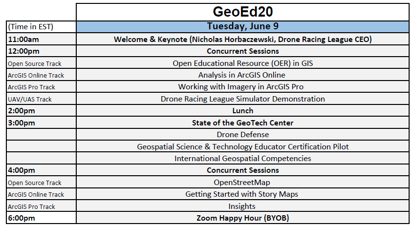
Day One – Session One – Tuesday, June 9 (12pm-2pm EST, 9am-11am PT)
Using and Building Open Educational Resources (OER) in Geospatial Technology and Geography: This session will discuss the open educational resource (OER) movement, show examples of OER, and showcase tools and implementation methods. Presented by: Adam Dastrup, GeoTech Center Analysis in ArcGIS Online: This session will showcase and demonstrate the analysis tools in ArcGIS Online. Additionally, curriculum resources associated with analysis in ArcGIS Online will be showcased and discussed. Presented by: Joseph Kerski, Esri Working with Imagery in ArcGIS Pro: This workshop introduces some of the image interpretation and enhancement tools of ArcGIS Pro. Using real data, participants will learn to process, analyze, enhance, correct, and extract information from visual imagery. Presented by: Ken Yanow, GeoTech Center Using the Drone Racing League Simulator: In April 2020, the Drone Racing League announced that its online drone simulator could be free to educators for use in their remote and online classroom. This session will provide an overview and demonstration of the DRL simulator. Presented by: Chris Cruz, GeoTech Center Day One – Session Two - Tuesday, June 9 (4pm-6pm EST, 1pm-3pm PT) OpenStreetMap: Curious about OpenStreetMap? Have you wondered how to incorporate open mapping in class? This session will offer a brief introduction to OpenStreetMap and the TeachOSM project; what it is, how it works, and why OSM excels as a tool for teaching. The introduction will be followed by a hands-on workshop where we'll train you on open mapping methods and you'll make your first edits on OpenStreetMap. Bring a laptop, a mouse, and your enthusiasm and we'll get you started mapping. Presented by: Steven Johnson, OpenStreetMap Getting Started with the NEW Story Maps: This session will demonstrate how to build ArcGIS Story Maps and will discuss recent updates to the product. Additionally, this session will talk about various ways that story maps can be used in the remote and online classroom. Presented by: Nicole Ernst, GeoTech Center Insights: Esri Insights allows the user to couple geographically represented data (maps) with analytical data (charts, tables). This session will show the steps in creating an insight page with information stored in ArcGIS Online. During the workshop questions will be taken from the participants. The participants will receive access to data, handouts and links to the presentations. The instructor will also be available to assist the learner after the conference. Presented by: Vince DiNoto, GeoTech Center |
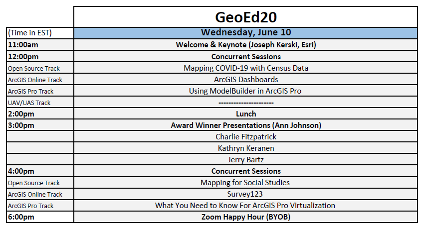
Day Two – Session One - Wednesday, June 10 (12pm-2pm EST, 9am-11am PT)
COVID-19 and Census Data: This session will explore the new Census data site https://data.census.gov and demonstrate how to navigate the site as well as find data for demographic projects. The session will feature how this site can be used to analyze COVID-19 vulnerable populations. Presented by: Adam Dastrup, GeoTech Center ArcGIS Dashboards: During the COVID-19 crisis, dashboards have been used to convey information by using location based analytics and visualizations. This session will explore “why” dashboards are helpful for decision-making and “how” GIS Specialists support Public Safety decision makers, by identifying core information needs in advance of disasters. For example, imagine supporting a search and rescue team during a large hurricane response, do you want to start creating a dashboard from scratch or build upon what you already know is important? While we will focus on public safety as an industry, many of the principles are applicable to other industries and educators preparing the next generation. Presented by: Paul Doherty, NAPSG Foundation & Derrick Law, Esri Using ModelBuilder in ArcGIS Pro: This session will introduce participants to the purpose of models and their components in ArcGIS Pro. Through a combination of demonstrations and hands-on activities, participants will learn the basics of ModelBuilder in ArcGIS Pro, as well as more advanced topics such as the applications of iterators and batch processing. This session is designed for current ArcGIS Pro users with little to no experience in ModelBuilder. Presented by: Wing Cheung, GeoTech Center Day Two – Session Two – Wednesday, June 10 (4pm-6pm EST, 1pm-3pm PT) Mapping for Social Studies: The Armed Conflict Location & Event Data Project (ACLED) is a disaggregated conflict data collection, analysis, and crisis mapping project. ACLED provides real-time data on the dates, actors, types of violence, locations, and fatalities of all reported political violence and protest events across nearly 150 countries around the world. The ACLED team conducts analysis to describe, explore and test conflict scenarios, and makes both data and analysis open to free use by the public. Teachers can use the ACLED dashboard to examine the spatial and temporal attributes of conflicts. This presentation will illustrate its use in a freshman level college course. Students will learn how to use the dashboard and complete geographical research to compare and contrast conflicts in different countries. The presentation will also show how to expand your analysis by downloading the data from the website and then uploading it into ArcGIS Online. Presented by: Tom Mueller, GeoTech Center Fun with Survey123: This session will demonstrate how to use the web based Survey123 application and then discuss ways that it can be used to create fun data collection projects for students. Presented by: Vince DiNoto, GeoTech Center Virtualization of ArcGIS Pro:With colleges and universities having to move their teaching online due to COVID-19, this session will discuss virtualization options of ArcGIS Pro. Presented by: Brian Baldwin & Canserina Kurnia, Esri Education Team |
Proposed Schedule
| Day 1.pdf | |
| File Size: | 107 kb |
| File Type: | |
| Day 2.pdf | |
| File Size: | 109 kb |
| File Type: | |


