GeoTech Center
  • HOME
  • EVENTS AND NEWS
    • GeoEd '20 >
      • GeoEd Conference Archives
    • Regional Workshops 2019
    • Virtual Workshops 2020
    • Geospatial Education Awards
    • Geospatial Technology Skills Competition Winner
    • GIS Articles
    • Newsletters
    • Other Events >
      • ATE Central Events
      • SCATE - Teaching Technicans Events
    • Webinars Series >
      • Webinar Archives
  • RESEARCH STUDIES
    • GTCM
    • Q Methodology
  • EDUCATION
    • Concept Modules and Demonstration Videos​
    • DACUM Results >
      • DACUM Research Chart for Geospatial Intelligence Specialist
      • DACUM Research Chart for Unmanned Aircraft Systems Operations Technician
      • GTCM Meta-DACUM
    • Developing a GTCM Modeled Geospatial Program
    • Geospatial Mentors
    • GeoTech Center National Program Locator
    • GeoTech Center's Presentations >
      • ATE PI 2019
    • Map Library and Data Resources
    • Model Courses
    • Supporting Your Program
    • Syllabi Repository >
      • Upload Syllabi Repository
    • Virtual GIS Day 2020 - Session Recordings
    • Virtual Office Hours
  • PROFESSIONAL DEVELOPMENT
    • ADA (Section 508)
    • Geotech Center Remote Sensing Workshop
    • Geospatial Websites
    • Personal Assessment Tool
    • Veterans' Resources >
      • Institutions of Higher Education >
        • Military Friendly Colleges
        • Servicemembers Opportunity Colleges >
          • Principles
          • Institutional Membership
          • Conditions for Membership
          • Criteria
          • Institutional Operating Guidelines
          • Standards of Good Practice
          • Principles for Higher Education Institutions
        • Voluntary Education Program
      • Joint Services Transcript
      • Military Crosswalk of Competencies
      • Military to Civilian Occupation Translator
      • Useful Web Links for Veterans and Service Members
  • CENTER INFORMATION
    • Central Office
    • Director
    • Associate Directors /Co-Principal Investigator
    • Assistant Director / Senior Team
    • National Visiting Committee
    • Center Partners
    • Professional Organizations
    • Become a Member
  • CONTACT US

Geospatial Websites

College Completion Rates by State icon.
College Completion Rates by State
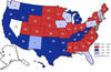
For the first time ever, the profiles from the 33 states in blue allow you to learn about full time, part time, or transfer students, pursuing certificates, taking remedial courses, transfer, or are older. We now have a much more complete picture of where we stand … and what needs to be done to ensure that all students have a fair shot at success.

GIS Stack Exchange icon.
GIS Stack Exchange
This is a free, community driven Q&A for cartographers, geographers and GIS professionals. It is a part of the Stack Exchange network of Q&A websites, and it was created through the open democratic process defined at Stack Exchange Area 51.

Accelerating Opportunities Website icon.
Accelerating Opportunities Website
By increasing the number of adults who complete postsecondary credentials, we can make the most of our human capital and help lift the economy.

Become a Member
Geospatial Resources
GeoTech Center's Presentations
Regional Workshops
GTCM & Meta-DACUM Curriculum Guidelines
Map Library and Data
Veterans' Resources
Partners


Copyrighted ©2020  Jefferson Community and Technical College • 1000 Community College Dr. • Louisville, KY 40272 • (502) 213 - GEOT (4368) •JF-GeoTech@kctcs.edu 
​NSF: DUE 1304591, DUE 1644409
, DUE 1700496, DUE 1937177, DUE 1938717, and DUE 1937237
Opinions expressed are those of the authors and not necessarily those of the National Science Foundation. 
National Science Foundation