
Supporting Your Program 2.0
This page contains information to help you maintain and improve your existing geospatial program. You will find information on program support for expanding your curriculum, updating your equipment and software, and improving your professional skills as both a technologist and educator. Also included are ways to use the technology for administrative purposes such as student tracking, facilities management and campus mapping.

Recruiting Women into Technology
Help women and girls think about careers they might not have considered before, and increase the number of female students in your technology classes.
Help women and girls think about careers they might not have considered before, and increase the number of female students in your technology classes.
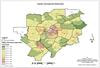
College Administrative Uses of GIS Share This College Administrative Uses of GIS
One of the ways to support a geospatial program is to show your college administration how the technology can help them make better, cost effective decisions. Jefferson Community and Technical College did just that with a studycarried out by Vince DiNoto using spatial analysis to look at students, census data and college locations. The study provided administration with easily understood maps to visualize fairly complex analysis. If you have examples of how you have engaged your administration in the use of geospatial technology, we would like to share your story. Please send your story to Ann Johnson at [email protected] or [email protected].
One of the ways to support a geospatial program is to show your college administration how the technology can help them make better, cost effective decisions. Jefferson Community and Technical College did just that with a studycarried out by Vince DiNoto using spatial analysis to look at students, census data and college locations. The study provided administration with easily understood maps to visualize fairly complex analysis. If you have examples of how you have engaged your administration in the use of geospatial technology, we would like to share your story. Please send your story to Ann Johnson at [email protected] or [email protected].

Partnering With Your Industry Advisory Board
Many schools and programs have advisory boards that function as little more than a fundraising pool or an audience for the reading of the annual report. Ideally, an advisory board should team with the school to drive the strategic direction while providing advice on various important issues. Having the right group of people on the board is a key factor in determining how effective it will be.
Many schools and programs have advisory boards that function as little more than a fundraising pool or an audience for the reading of the annual report. Ideally, an advisory board should team with the school to drive the strategic direction while providing advice on various important issues. Having the right group of people on the board is a key factor in determining how effective it will be.
