GeoTech Center
  • HOME
  • NEWS AND EVENTS
    • Excellence in Geospatial Education Awards
  • RESEARCH STUDIES
  • EDUCATION
  • PROFESSIONAL DEVELOPMENT
  • CENTER INFORMATION
  • CONTACT US
  • New Geospatial Tools Self Assessment Tool

GIS Articles

Discover free public data, tools, and resources from GeoTech Center
Picture


Picture

Breaking Ground - Women in GIS?
​

By Emell Derra - March 2021

Picture

EUROGEO and GeoTech Center Become Partners
​

EUROGEO and GeoTech Center have signed  a Memorandum of Understanding - early May 2020

Picture

GIS Jobs: Current Industry Expectations
​

By Sarah Hibdon, Robert Hickey, Jamie Cannon - May 15, 2019

Picture

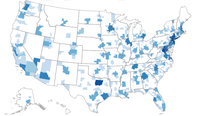
Where the Drone Jobs will Land?
​

By Kaveh Waddell - November 9, 2019


Picture

NSF Announces Regional Testbed Dedicated to UAS Integration
​

By Betsy Lillian - September 18,2019

Picture

What Makes a Good UAS/Drone Operations Technician?
​

By Wing Cheung - June 26, 2019

Picture

What does the FAA Reauthorization Act Mean for Educational & Recreational Flyers?

By Wing Cheung - June 26, 2019

Picture

Five Tips to Make Your Story Map POP!
​​

By Wing Cheung - September 19, 2018


Picture

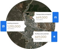
Environmental Insights Explorer
​

By Google Sustainability - 2018

Picture

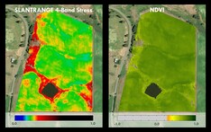
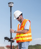
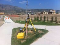
Choosing the Right Sensor
​

By Ken Yanow - November 15, 2017

Picture

Get the GIST!
​

By Jonathon Little - 2016

Picture

Choosing the Appropriate UAS Mapping and Photogrammetry Software

By Wing Cheung, Mark Bealo - September 20, 2017r


Picture

10 Tips for Passing the FAA’s Part 107 Knowledge Exam

By Wing Cheung, Sean Figg - November 2, 2016

Picture

On Geospatial Information and the Sustainable Development Goals​

By Joseph Kerski - August 28, 2016

Picture

5 ways to get a job in the Geo-Industry​
​

By Digital Geography - August 2, 2016

Picture

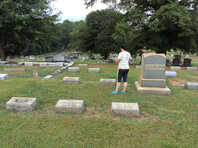
Witness to the Web of Life​
​

By Carla Wheeler - August 2016


Picture

Datums Still Matter ​
​

By Joseph Kerski August 14, 2016

Picture

Geocoding in GIS: ArcGIS, QGIS, Leaflet​
​

By Digital Geography July 17, 2016

Picture

ArcGIS Helps the City of Marietta, Georgia, Dig into Its History

By Ross Brewer July 2016

Picture

Accessing Landsat and Sentinel-2 on Amazon Web Services

By Digital Geography June 28, 2016
Become a Member
Geospatial Resources
GeoTech Center's Presentations
Workshops
GTCM & Meta-DACUM Curriculum Guidelines
Map Library and Data
Veterans' Resources
Partners


Copyrighted ©2024  Jefferson Community and Technical College • 1000 Community College Dr. • Louisville, KY 40272 • (502) 213 - GEOT (4368) •JF-[email protected] 
​NSF: DUE 1304591, DUE 1644409
, DUE 1700496, DUE 1937177, DUE 1938717, DUE 1937237, DUE 2202038, and DUE 2500731
Opinions expressed are those of the authors and not necessarily those of the National Science Foundation. 
National Science Foundation