
Welcome to the National Geospatial Technology Center of Excellence
Discover free public data, tools, and resources from GeoTech Center

|
|

|
Concept Modules and Demo VideosThis is probably the most asked question posed to those in the Geographic Information Systems (GIS) field
|
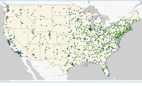
Geospatial Education Program FinderThis is probably the most asked question posed to those in the Geographic Information Systems (GIS) field
|
Model CoursesThis is probably the most asked question posed to those in the Geographic Information Systems (GIS) field
|
|
|
|
|
Geospatial Educator's Certification Program - GeoEdCThis is probably the most asked question posed to those in the Geographic Information Systems (GIS) field
|
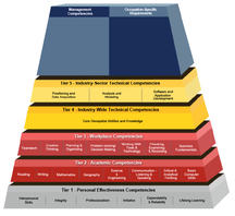
Geospatial Technology Competency Model - GTCMThis is probably the most asked question posed to those in the Geographic Information Systems (GIS) field
|
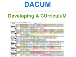
Geospatial Technology - Meta-DACUMThis is probably the most asked question posed to those in the Geographic Information Systems (GIS) field
|

|

|

|
NewsThis is probably the most asked question posed to those in the Geographic Information Systems (GIS) field
|
EventsThis is probably the most asked question posed to those in the Geographic Information Systems (GIS) field
|
NewsletterThis is probably the most asked question posed to those in the Geographic Information Systems (GIS) field
|

|

|
|
CalendarThis is probably the most asked question posed to those in the Geographic Information Systems (GIS) field
|
Personal Assessment ToolThis is probably the most asked question posed to those in the Geographic Information Systems (GIS) field
|
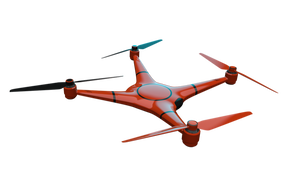
Unmanned Aircraft System - UASThis is probably the most asked question posed to those in the Geographic Information Systems (GIS) field
|

|

|

|
UAS MOOC - Drone Safety and ApplicationsThis is probably the most asked question posed to those in the Geographic Information Systems (GIS) field
|
WorkshopsThis is probably the most asked question posed to those in the Geographic Information Systems (GIS) field
|
Geospatial Awareness MOOCThis is probably the most asked question posed to those in the Geographic Information Systems (GIS) field
|
